Tourism web of Chinchón (Spain)


Routes
Laguna de San Juan route
 Download route's map
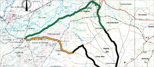
The route we suggest at this time is close one of the emblematic natural places of the Community of Madrid: the wildlife refuge of Laguna de San Juan, protected since 1991. It is a wetland of about 47 acres of which 4 correspond to the water surface and the rest to the marsh vegetation that surrounds and protects. This combination of water and vegetation provides ideal shelter for birds settlement characteristic of these marsh ecosystems.
The lagoon, in the catchment area of the river Tajuña, is nestled at the base of the gypsum hills, typical of the left bank of the river, hills that are also walked in the road, thus providing an itinerary that includes several ecosystems: marshy zone, gypsum hills and farmland. It is a long journey of about 19 kilometers and a half. To do this you need to drive to the village of Villaconejos where this route begins.
There are no shadow zones in this route, so it's recommended to hit the road in little heat days. You should also consider bring water and binoculars to observe birds. The route starts and finishes in Villaconejos, a town known for its melons.
"Las Cuestas" path
The tour begins in the Plaza Mayor. To the left of the town hall we go down the Santa Ana street, which is directed to the hermitage of the same name. We left the chapel and go out of the village along the road before us that goes between melon crops. The track in good condition reaches a branch that arises on the left just before a farmhouse, which we have to continue the route. This again has a strong upward path in worse shape and in some areas quite rocky. It's Valdezarza road, and the hills to which it is addressed are known as "las cuestas", a name that fits perfectly with the slope. But the ascension ends and the road describes a series of curves to fit the terrain hills, olive groves and scrub.
Swallows romp with the wind and seem to follow us on our way. We will continue to go down without turning off the main road and reach a crossroads between cereal crops.
"La Laguna de San Juan" path
At this junction we should go straight and continue on the path that gently ascends between gypsiferous outcrops on the floor. A few meters ahead we leave a path and continue ascending till sight the ruins of La Cubilla, an old farmhouse that has given its name to the village in which we move immediately turning left at the first farm fence. We'll begin a long descent and quite steep. We will reach a junction where the path to choose is the left side to keep going down. At the next crossroad we should turn right and right again at the last crossroad next to a light transformer. We left the track urbanization and turn left. This track is the Path of the White cattle route that extends for several kilometers and connecting the remaining wetland area between the river channel and Tajuña gypsum hills that define its basin.
A few meters ahead, a signpost of the Laguna de San Juan shows us the way forward. We pass the house of the wildlife refuge where a panel explains the most important features of this enclave. Later we will find a bird observatory and the drain of the Laguna. If we don't make any noise, we can see the variety of birds that inhabit the lake, so it is essential to bring binoculars. Some posters will help us to identify both its appearance and by the time of where we are.
We left the observatory and continue along the track between the Tajuña plain of crops, guessed thanks to coastal thicket reveals the flow of the river to our right. Along the way many birds will cross before us: swallows, bee-eaters and airplanes. The last ones are installed in the cliffs on our left. We may also see some cattle egret and a marsh harrier. The track ends with Titulcia road in the curve for the descending path bridges. But our route turns 360 ° in order to enter the open hills to our left.
"La Casa de los Montero" path
We begin the ascent to the hills on a road that is guessed from the abundant aquatic vegetation we have left. As we go up the path gets clear and we pass in front of Las Cuevas del Romeral. We can see clearly how the road goes through the hillside to slowly move up between abundant esparto bush.
At the end of the valley we cross to the other side where the coscoja begins to proliferate, spiny shrub with leaves that form a dense tangle very difficult to penetrate. They are of the genus Quercus as can be seen by its leaves and acorns. The road is difficult because the ramps that have to be overcome to reach La Casa de los Montero, a crumbling old mansion that dominates the surrounding terrain. At this point we'll continue along the detour down to the left, and the other way just in the house.
"El Balneario de Vilacabras" path
We'll descend to another road that we follow right onto the farm we have in front. Upon reaching it, we'll continue without turning leaving it to the right, and after a short but steep slope we reach the highest point of the route, from where we start to descend very smoothly between cereal fields, olive groves and vineyards. Without deviating, we reach another track just below a line of light. Here we turn left first and then continue straight. We must get to the second intersection, where if we want, we can come to nearby Fuente de Villacabras, a spring of water that once led to the creation of a spa for its healing qualities. To get there we need to turn left at this junction towards the ruins and trees that can be seen in the distance and continue along the road to reach the semi-covert source under a fig tree. A little further down can be found the flooded caves that once supplied water to the spa located at the top and only the foundations remain. All of this with abundant aquatic vegetation that leverages the permanent presence of water to grow up.
We come back the same way and at the junction continue without turning off. In case that we didn't get closer to the fountain before, the detour at the intersection had to be to the right. Likewise, the road will take us straight to Villaconejos happening just before reaching the village in front of the cave of the Friars, where the inscription on the cover indicates it was built over two centuries ago.
We enter the village under the tower of the mobile phone through the Bayona street and we keep moving without turning off to Plaza de la Alegría. From here, you can see the towers of the church, from where we head down across the street of the same name which ends in the Plaza Mayor. We'll finish here our trail.