Tourism web of Chinchón (Spain)


Routes
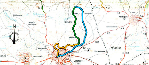
Valdezarza route
 Download route's map
Chinchón's Plaza Mayor serves as frame to start the route. Let's make a short tour, about 11 Km.
The main attraction of this route is passing through the only found quejigar in the area. The quejigares are the more austere and more extended of oaks, corks, etc. It could be said that they are oaks with ilex characteristics. In any case the quejigos may appear in many different forms and in varied and disparate environments. They form isolated clumps, or tagled "jungles" with huge feet tangled near intricate thickets. Its location in this area confirms the nature of "all-terrain" of this species.
The first part of the tour takes place in the upper part of the valley, thus allowing us to enjoy a wide landscape where you can see large areas of olive groves and vineyards and pine forests that climb the steepest slopes.
"La Casa de la Pinilla" path
We left the Plaza Mayor through Grande street and in the Plaza de los Hermanos Ortiz de Zárate we continue down the road of Teniente Ortiz de Zárate street that leads to the road of Valdelaguna, left the civil guard barracks on the left and out of the road to the left along the road that has a sign indicating Sources. We started down and get into the quejigar. We went down to the next intersection to the right until you reach the fountains and watering. We continue up the hill opposite leaving leaving the source to the left and among the oaks reach a very good track that leads through the high Valdezarza Valley.
Continue along this track until we reach a fork, where we will continue to the left in a long down. We will have to be vigilant to take the exit on the left that comes just ahead of a pine forest in the turn to the right.
"Valdezarza" path
We continue along this new track leaving the pines on our right to exit to the Valdezarza's valley where we start a long stretch of gentle slope that takes us to the sink and sources.
"El Campo Santo" path
We left the sink and began to climb gently to reach the sources of the start of the route. Here is the resting place of Valdezarza. From here comes a cattle route that reaches Chinchón. This is Valdezarza's trail. From here we continue our way up the ramp we were walking down before, but now we go straight. We continue bordering the hill and reach the cemetery. Then we left the cattle route and take a path to our right that runs the cemetery wall. The road continues up the side lead down to another track in better shape. We found other cattle route, the path of the Cuesta del Gramoso, taked on our left and after a few meters we reach the road of Chinchón to Morata de Tajuña.
We cross the road and continue along the road that runs in front of the people. Is the Cuesta Colovera. In the first turn right we head towards the town center. Go straight to the monumental set that form the Palace, the Tower, the Teatro Lope de Vega and the Iglesia de Nuestra Señora de la Asunción in the square. From this square there is a magnificent view of Chinchon, with its square bottom and the Castillo de los Condes as a watchtower opposite. Now we just go down to the Plaza Mayor through cobblestone streets that access it and terminate the tour.